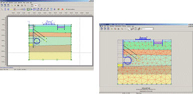
With PLAXIS, users can model a wide range of geotechnical problems such as foundation design, slope stability analysis, excavation and tunneling, retaining wall design, and ground improvement techniques. The software provides a user-friendly interface for creating finite element models, defining material properties, applying loads and boundary conditions, and visualizing results in both 2D and 3D.
Finite element method in geotechnical engineering: PLAXIS
![]()
Geotechnical documentation: GEOSTAR, GEOPLAN, STRATER
Overall, GEOSTAR, GEOPLAN, and STRATER play crucial roles in the geotechnical industry by providing comprehensive solutions for data management, analysis, and visualization. These software tools empower professionals to make informed decisions, optimize designs, and communicate effectively with stakeholders throughout the project lifecycle.


Stress and strain in soil SIGMA/W
SIGMA/W is a powerful software tool used in geotechnical engineering to analyze stress and strain behavior in soil. It employs advanced numerical methods to simulate the response of soil masses to various loading conditions, helping engineers assess stability, settlement, and deformation characteristics of soil structures.
With SIGMA/W, users can model complex geotechnical problems such as embankments, retaining walls, deep excavations, and foundations. The software allows for the consideration of factors like soil properties, groundwater conditions, and external loads to accurately predict stress distribution and deformation patterns within the soil mass.

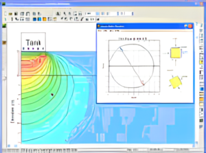
Slope stability SLOPE/W
SLOPE/W is a specialized software tool used in geotechnical engineering for analyzing the stability of slopes and embankments. It employs advanced numerical techniques to assess factors such as soil properties, groundwater conditions, and external loads, allowing engineers to predict the likelihood of slope failure and optimize designs for safety and stability.
With SLOPE/W, users can model a wide range of slope configurations, including natural slopes, embankments, and excavations. The software provides tools for conducting comprehensive stability analyses, considering factors such as soil strength, pore water pressure, and slope geometry. By simulating various scenarios and applying different stabilization measures, engineers can evaluate the performance of slope designs and mitigate potential risks associated with instability.

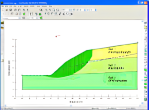
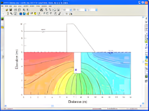
Confined and unconfined flow of water through soil SEEP/W
SEEP/W is a specialized software tool used in geotechnical engineering to analyze the flow of water through soil under confined and unconfined conditions. It employs advanced numerical methods to simulate seepage phenomena, helping engineers understand groundwater behavior and its impact on infrastructure projects.
With SEEP/W, users can model various scenarios involving water flow through soil, such as seepage beneath dams, embankments, and levees, as well as drainage systems and groundwater remediation projects. The software allows for the consideration of factors such as soil properties, hydraulic conductivity, boundary conditions, and changes in water table elevation, enabling engineers to predict seepage rates, pore water pressures, and flow patterns within the soil mass.

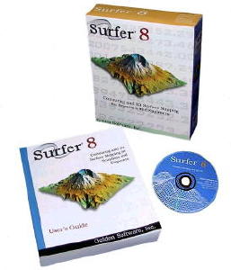
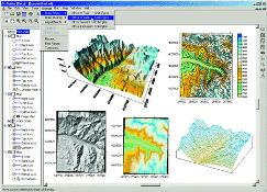
Supporting software: GRAPHER, SURFER
GRAPHER is a versatile graphing tool that allows users to create a wide range of 2D and 3D graphs, plots, and charts. It provides intuitive features for displaying mathematical functions, experimental data, and statistical analyses in a visually appealing manner. GRAPHER is widely used by scientists, engineers, educators, and researchers to illustrate relationships, trends, and patterns in data, facilitating clear and concise communication of complex information.
SURFER, on the other hand, is a comprehensive mapping and spatial analysis software package. It enables users to create high-quality contour maps, surface plots, and 3D terrain models from various types of geospatial data, including elevation models, aerial photographs, and geological surveys. SURFER’s advanced mapping capabilities make it a valuable tool for geologists, environmental scientists, civil engineers, and urban planners involved in land use planning, resource management, and environmental monitoring projects.

Strengthened soil: design supporting software of soil strengthening products producers
Design supporting software provided by soil strengthening product producers offers engineers and designers a specialized toolset tailored to optimize the use of their specific soil reinforcement products. These software packages are designed to streamline the design process for reinforced soil structures, such as retaining walls, slopes, embankments, and pavements.
By utilizing such software, engineers can input site-specific parameters and project requirements to generate detailed design solutions incorporating the manufacturer’s soil reinforcement products. These tools typically offer features for analyzing soil properties, determining optimal reinforcement layouts, and evaluating the performance of the reinforced soil structure under various loading conditions.
Drafting: AUTOCAD
AutoCAD is a widely-used drafting and design software developed by Autodesk. It allows architects, engineers, designers, and drafters to create precise 2D and 3D drawings and models for a variety of industries including architecture, engineering, construction, manufacturing, and more.
With AutoCAD, users can efficiently draft and document their designs with accuracy and flexibility. The software offers a wide range of drawing tools, annotation features, and editing capabilities to create detailed plans, blueprints, schematics, and technical illustrations. Additionally, AutoCAD supports collaboration and sharing of designs through its compatibility with various file formats and integration with cloud-based services.